Leaving Snow And More Thunderstorms

Day 2:

Jacks Creek (10.9) to North Fork Savery Creek (26.4) – 15.5 miles

20170606_173855-01

It was chilly this morning and stayed in my sleeping bag till 8am. I had a Nutrigrain bar for breakfast and filled up my water with some very cold water from the creek. It is 7.8 miles to the next water source and hopefully we will leave the snow soon so we can go a little bit faster.  Continue reading

Day 5 – Going Home

Woke up at 7:00am. Tossed and turned a little bit, my muscles are a little sore but nothing major. I did wake up to a swollen bottom lip for some unknown reason. We slowly packed up and got moving. The bushwacking near the water is not fun at all but noticed if we go higher up, there was less brush and spent more time walking through the forest and a lot of downed trees to climb over. We did have a few water crossings which we then took off our shoes and socks and marched on through. It was mostly cloudy so not sure if to expect rain, but I hope not. It wasn’t long before we reached the Six Mile Camp trail. Only seven miles left to the road where we exit.

132

Dense brush – Do you see Brien?

We did pass one guy who was heading up towards Dome Peak and Cub Lake and asked about the climbers route which we know we had passed cause it also meets and Six Mile Camp. We informed him which way we came out and he said he had a GPS with him that he is going to rely on. We said our goodbyes and quickly got moving down the trail. Even though most of the boardwalks we came across were destroyed, the trail was otherwise in good condition and mostly flat with a little decline.

All a sudden we were at the road, we did it! We completed the Ptarmigan Traverse from start to end with a little route twist at the end that gave us the same results. Time for a high five and food. We made a snack while we waited to find a ride back into town or start walking. My pants were torn into pieces thanks to the use of crampons, but that didn’t phase me one bit, worth it!

134

Aftermath

We spoke to a ranger who was driving through the area and we talked for a few minutes. It wasn’t more then 30 minutes later an older gentleman drove up and found us and offered us a ride back into the town of Darrington. He was just driving up in the area looking for an old campground he came to many years ago and just wanted to see if it was still around. I knew the area well and was able to help him see which we just drove past anyways once he saw it was still there. We shared some stories and then he dropped us off at a gas station where we called for our ride. We walked next door to The Burger Barn where we got a delicious burger and fries with a milkshake. Great way to end an amazing adventure. Now to go home and see my son!

Day 4 – Detours and a Bear

Woke up at 1:00am, it was silent as the wind had stopped. It was very peaceful but cold, 34 degrees inside my tent to be exact. I woke up again at 5:45am to Brien telling me I need to look outside. I unzipped my tent and stuck my head out and saw the most stunning sunrise I have every witnessed. I quickly took out my camera and started taking photos. I even got out of my tent not fully dressed and kept taking photos of all directions. The cold did not bother me one bit.

94

Started packing up around 7:15am and hoping the weather holds out so we can get to Cub Lake. It will be a long day. Even though we are one day behind cause of the storm, I am not worried at all. I told family and friends that I was expected back on Friday, but not to worry unless they don’t hear anything by Sunday night, and even then to not worry. That gives me two full days if anything went wrong to fix it myself. We were off and said goodbye to the two climbers. It was nice to leave early and walk on crunchy snow. Crampons had better grip that way. We are about to cross South Cascade Glacier which I was told was the deepest glacier in the lower 48. I haven’t verified this but as soon as I saw it, I believe it. It’s massive! We crossed South Cascade Glacier and I sure felt small walking on it. I felt like I was walking across Antarctica and the only thing missing was the penguins.

104

South Cascade Glacier

We arrived at the top of the pass after an easy glacier crossing and the views keep getting better! Looking down on White Rock Lakes I was surprised to see some of the bluest water I have ever seen in my life. Lakes were partially frozen over and then the view of Dana Glacier in the background, just beautiful. We carefully worked our way down the steep snow until we hit the first lake and walked around to a snow free place between both lakes where we had lunch and figure out what to do next.

107

White Rock Lakes

Dana Glacier is not what we expected. We checked the map multiple times to make sure that was were we were supposed to go next, yep, that’t it. There is no way we can safely do that without rope. The steep face of that mountain of all snow looking right at us was not what we were expecting. Everything we read showed it was very steep at times and a lot of rock ribs to get through. With rope and climbing gear, it can be done, heck it can be done without rope of course but I wasn’t willing to bet my life on it. The only exit that has been talked about was going East along the West Fork of Agnes Creek through very heavy bush wacking until you hit the Pacific Crest Trail which was 10-13 miles away. Now once you reach Cub Lake, you have to bushwack anyways to get out to the Suiattle River road. So we had some thinking to do.

111

Dana Glacier

After looking at maps, we decided to maybe try something that maybe no one has ever done being it was never talked about in anything we have seen or even offered as an alternate to get to the Suiattle River road. We would go Southwest up the snow over a ridge and drop down into a valley and follow the creek until we found a small trail that took us right into the Suiattle River road and come out at the exact same spot we would of came out at if we went to Cub Lake.

We started around the lake and working our way up to the pass. It started off nice but quickly and got steep and a little iffy, but it had to be way safer then trying Dana Glacier. As I neared the top my hiking poles went straight through the snow a couple times and really had to take it slow and careful. Once at the top, we could look a ways through the valley, but not as far as before. We are lower then we have been this whole trip and the tree line is not far away now. Now was the time to figure out how we would get down from up here, this hasn’t been done before as far as we know and no information about it. Going to the right looks nice, but there is a waterfall and cliff face which didn’t allow us to go that way, and to the left was nearly a vertical cliff as well. so we zig zaged our way down carefully and managed to get to the creek and before we knew it, we were walking through a meadow by the creek and into the trees again!

120

Brien scanning terrain

Brien mentioned that we should probably start to keep our eyes out for bears and other wildlife, and as soon as he made that comment, I spotted a bear about 50 yards to our left just sitting in a patch of snow staring at us. We both stopped to take a couple photos and I bet he was surprised to see out here but he didn’t mind one bit. After a couple minutes, he got up and just slowly walked away. We continued into the woods and started to drop in the heavily forested land with a lot of alders and brush. It got steeper and steeper which we expected by looking at the map but figured we would keep going until it leveled out. We got to the point where we were grabbing onto small alders and tree branches using them almost as rope to lower ourselves down. All a sudden the terrain disappeared and just dropped. We were standing at the top of a cliff in the trees and could not go another step further. We scrambled up a little ways and continued to the South a little bit and tried to drop further and ran into a cliff again.

125

Black bear hanging out

After another 30 minutes of trying to get lower we reached a spot where it looked like we could get down, but first it required taking another chance along a big rock face. At the top of the rock we had to grab small alders and use them almost as a swing to hold us up and carefully get across without the alders breaking. Once across the face of the rock wall, weave our way down through a tree and then done. Once we got past that portion, it was another fairly easy 15 minutes before we found the creek again where we got water and took a break and shouldn’t be to hard from here, just follow the creek out. We took off our shoes and socks and let our feet relax in the cold water which felt amazing.

129

Following the creek out

Once we got going again, following the creek was tougher then we expected. Heavy brush on both sides made it tough to walk along the side and the further down we went, the more other water sources flowed into the creek making it grow bigger and bigger until we had to change our plan and stay to the left of the creek and start bushwacking. At times it was so thick, Brien would be only five feet in front of me and I could not see him at all. This was a very slow process. We were hoping to make it to the six mile trail camp where we could find a place to camp for the night, but realized we would going to end up almost two miles short and with the heavy bushwacking, we were only averaging a quarter mile per hour. We found a place in the woods to set up both our tents and hopefully this isn’t near where mountain lions or bears visit much. I plan on sleeping with my food, which is something I did nightly while hiking on the Pacific Crest Trail and I don’t mind doing it. Most truly wild animals are just curious of humans anyways and not looking for your food. 8:30pm and falling asleep now.

131

Last night of sleep

Day 3 – Challenge After Challenge

I woke up around 1:00am. The winds seem to have calmed down a little bit, so I stuck my head outside and shined my light outside to still be greeted by thick fog. I fell back asleep and woke up at 5:00am to the sound of rain that was of and on until about 7:30am. Talking with Brien, and while I am dry in my tent, he is not so lucky and got a little wet from all the heavy rains overnight. We are still in the fog but decided we are going to go for it as we have all day and at some point we’re expecting clouds to break apart. Hopefully we can get over the top and to the Eastern side of the mountains where it generally is protected from rains.

We quickly packed up and started to put on out boots and crampons. We have been stuck in place for nearly 24 hours and were ready to go. Soon as boots were laced up, all a sudden the clouds quickly started to break apart and you could bits of blue sky which was an amazing feeling of all a sudden we got moving fast using the blue sky as motivation. We worked out way up Middle Cascade Glacier navigating multiple crevasses and a couple snow bridges. I have hiked for nearly two decades and been through a lot of things, but glacier travel was new to me. It was beautiful and you can see and feel the power of these glaciers and it gave me a new appreciation I have yet to experience before this trip, but I was also aware of the dangerous and probably more cautious compared to someone who does this all the time. We made it to the top East notch just as the fog filled in the valley behind us. As we stepped into the notch looking into the Eastern side, my jaw dropped at the view. Blue skies ahead of us snow covered mountains in July with beautiful green valleys of land that most people will never see in person unless they fly above it.

50

Passing through the East Notch

We could see Ying Yang Lakes way out in the distance and Brien led the way down the very steep snow. Once we got to an elevation that appeared close to the lakes, we started to work our way to the right keeping the same elevtation. After awhile we realized we were too high up and would pass above the lakes. Using my Nikon 55-300mm lens, I was able to look in on the lake and see both climbers down at the lake packing up. We decided to take a break for a snack and so Brien could dry out some of his gear. Being after the lakes we had to go straight up in elevation to get up to the next big glacier crossing, we decided to skip on going to the lakes.

56

Drying out – Ying Yang Lakes Below

After an hour break, it was noon and we were packing up and moving on. I can see La Conte Glacier in the distance and that looks intimidating from a distance. It is supposed to be our most active and heavily-crevassed ice of the whole Ptarmigan Traverse. But before we can get to La Conte Glacier, we discovered we had a lot of obstacles to overcome first. First was straight up a near narrow snow finger that once you got to the top, it was nearly vertical. We could see the other two climbers nearing the top and they looked like tiny ants from where we were. Started our way up and the further we got up, the steeper it got, to the point I was almost climbing a snow ladder. Digging my hiking poles deep into the snow and two kicks with my crampons on each step to get a good grip. The last 30 yards was now vertical and I felt my left leg starting to cramp. I couldn’t rush the snow climb and risk slipping and falling nearly 300 feet. I felt standing in place for a break wasn’t the best idea either being the snow was becoming soft with the afternoon sun. I yelled up to Brien and asked him how safe he thinks it looks for me to jump the gap to the rock and climb straight up that, plus I could rest and stop the cramp. Brien’s opinion was to not go to the rock cause it didn’t look safe but he knows my limits. I probably should of listened to him, but instantly my instinct said get to the rocks sooner than later. I dug in a couple new steps to the edge of the snow and then made the two foot jump to the rocks. I was able to get a good grip and hang on, but quickly realized the rock was loose and breaking off a I looked down and watched the rock disappear through the gap under the snow. I now had to climb vertical for the next 30 yards, which might not seem very far, but with the backpack on wearing crampons and using every muscle knowing if I mess up, it very well could be game over. After a little bit, I made it safely to the top and will take the snow ladder next time. At least I can check that off the list of crazy things I have done.

67

300mm zoom at the final climb 

Onward, can’t be any tougher then what I just went through. Ops, spoke too soon. It is only a small section, but this may be the toughest test yet. It is a little hard to explain, but I will get a video posted of it hopefully soon. We had to climb down a small steep part and then there is a huge gap to get over to the other section of snow. In the middle of this gap, there is a small rock space to jump or work your way onto but don’t overshoot it otherwise you are falling underneath and will disappear to the point where you aren’t getting out. Once you make it onto the rock section, you have to jump that big gap into the edge of snow, which might not sound too bad, but if you overshoot the jump even a little, you are sliding straight down the steep slope and over the edge to who knows how many hundred feet (only know the drop from viewing it shortly before reaching this section). I managed to brace against the rock wall using all my force to keep me up and not falling down and get to the center of the rocks that would crumble and disappear like everything appears to do out here. I spent some more time calculating my jump and went for it and straddled the heck out of the snow with a leg on each side before climbing up to safety. Brien went through the same thing and we are not surprised but amazed by all the new challenges we keep facing each day. You are literally fighting for your life out here which is I know horrible to some people, but to me, I enjoy the adrenaline and rush. As crazy as it sounds, I can be scared for my life and enjoy it at the same time. I will mention that in my notes, I wrote I never want to have to do that last challenge again without ropes or even maybe with ropes.

I finally caught up to the other two climbers who were very happy with their ropes and ice ax. Walked through a couple sections where huge snow falls had happened from up above and we walked past some huge chunks of snow and ice. The view of La Conte Glacier was spectacular! We all went together through La Conte Glacier navigating a lot of huge crevasses and a few snow bridges. One snow bridge was probably only three feet wide and on the left side, you would slide down the steep slope for as far as you can see down and on the right, was a 50 foot fall with no way out. For being so narrow, its surprising how sturdy a snow bridge can be.

79

Two climbers (upper right)

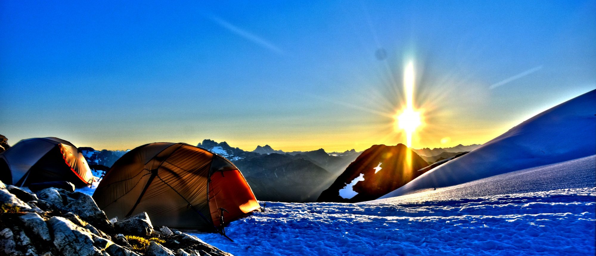
As we continued our way up to the top, clouds started to roll in and the winds started to kick up. We arrived at the top and end of Le Conte Mountain (7,300). It was 6:30pm and even though it was super windy, we all felt this was the best bet for a place to camp for the night. When the clouds allowed us to see, the view was amazing in every direction. I almost feel like I am on top of the world right now, this is what I hike and climb for! Winds were hitting around 45 mph and made setting up tents near impossible. We took turns helping each other setup our tents and used rocks to help secure my tent since there was no possible way to use stakes to secure the tent.

86

Camp on top of La Conte Mountain

Once camp was setup, my body was telling me to eat a lot, so I had a two dinners and consumed it all quickly. We did locate a small source of water about 50 feet away and I made some lemonade to go with dinner. Even though my phone battery was doing well, I decided to charge it a little using my Anker portable charger while taking a lot of photos. 9:00pm is here and it is time to go to sleep listening to the sounds of the winds blowing through the top of this mountain. Hoping for good weather tomorrow so we can make some good miles.

Day 2 – Stuck and Stormy

Woke up at 6:30am and had a quick breakfast and we quickly got moving as we know a storm may moving in anytime today. It was overcast, but we still could see enough to move on. 15 minutes into the day we found our last water source for awhile, so we stocked up. We crossed a couple snow fields before needing to put on crampons for the next to steep sections. Today we are expecting to climb up Middle Cascade Glacier and go through Spider-Formidable Col which is the East side notch. There are two places that can be crossed but since 1991, no one has admitted to crossing the West notch.

We arrived at the glacier around 9:30am and started to climb maybe 200-300 yards up until the fog surrounded us and we couldn’t see anywhere. We stopped at a rocky section that was actually somewhat flat and would be a great place to hang tight until it either cleared up or the other two climbers caught up with us and decide if we want to continue.

DSC_0312

Losing visibility

Around 10:00am, the rain started to fall and we decided to set up our tents and keep dry in case we end up being stuck for awhile. The winds started to pick up and we are guessing this is the storm we were expecting. This will set up back a day if we can’t go anywhere and being there are large crevasses in the glacier and all guide books say to rope up.

DSC_0310

A break in the weather

Made top roman around noon and still no sign of the other climbers. Can’t see anything in any direction and we are starting to accept the fact we are stuck for at least a day. We both have plenty of food and while I’m sure we can attempt to get to the top and over, would rather be safe and late and not rush and do something that can’t be reversed. Brien is inside his tent reading a book and I am playing Solitaire in my tent. We both are warm and dry as the rain keeps falling and winds are blowing us around as we are in a very exposed spot. At 1:00pm I popped my head out to see a curious hummingbird who greeted us and flew circles around our tents. Was not expecting to see on of those this high up and away from vegetation.

30 minutes later we located the two climbers in the snow working their way towards us. They took a much lower route than us. By 2:15, they made it to us. They left Kool Air Lake at 11:00am and they are following a GPS to find their way through the fog. They said they were keep following their GPS and get to Ying Yang Lakes before dark and offered if we wanted to follow. We thanked them but declined. They are roped together and by the time we pack up, we are still cutting it close with daylight. They were on their way by 3:10 and within a few minutes you could no longer see them as they disappeared quickly into the thick fog and up the glacier. Five minutes later the sky opened up and started dumping rain. I am glad we decided to stay now. I think they may turn around cause they did ask if there was room for two more tents if they needed. (They never came back)

DSC_0349

Off they go

Heavy rain lasted till 5:00pm and the strong winds continued to pummel us until about 6:00pm. Everything started to calm down and I walked around outside for a little bit to stretch my legs and see a whole 20 yards in any direction around me. Didn’t take long for the rain to come back and send me running back inside my tent. It’s 48 degrees inside my tent which is plenty warm enough to fall sleep no problem. Back to sleep at 8:00pm, which didn’t last long as I was woken at 9:45pm to the sounds of strong winds crashing into my tent and heavy downpour. Big Agnes Flycreek UL1 is an amazing tent I will say. I have used this tent for over three years including on the PCT and have always been dry and protected from winds with no structure failure. I enjoy the sounds of the winds and rain hitting my tent. It helps that I am dry, but something about those sounds that I enjoy and also help me sleep (Even if I do get woken up at times). Kinda like sleeping next to a river.